
Rim Fire, CA-STF-2857 Wildfire Tuolumne County FRA
Rim Fire Evacuations: Highway 108 Evacuation Advisory Extended to PinecrestReleased: 8:30 pm 8-26
There has been an evacuation advisory issued from Mi-Wok to Pinecrest along the Highway 108 corridor. This advisory has been issued by the Tuolumne County Sheriff's Office.
Update 8-28 0900: Wilkins NC IMT1; Lawshe CA IMT1 Unified Command
Update 8-26 1900: 160,980 acres, 20% contained, No expected containment date.
Wilkins NC IMT1; Lawshe CA IMT1 Unified Command
NEW Advisory Evacuation for all of Pine Mountain Lake has been issued.
Evacuations: Evacuation center is located at the Mother Lode Fairgrounds in Sonora.
The Southeast Blue Team assumed command of the Rim Fire today at 6:00 A.M and will remain unified command with CAL FIRE.
The Rim Fire is located within the Stanislaus National Forest on the Groveland Ranger District. The fire continues to increase in size and burn actively through the day and night. It continues burning east and has crossed the Yosemite National Park boundary. The fire also continues burning west toward the community of Pine Mountain Lake and northwest. Direct suppression efforts are occurring in the vicinity of communities and structural defense is in place.
3 miles northeast of Groveland, near Clavey River Canyon
ALL FURTHER UPDATES AT: http://calfire.blogspot.com/2013/08/rim-fire-update-as-of-august-27-2013.html
Latest Official Information:
 |
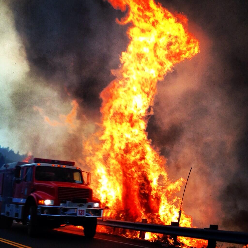
| Rim Fire 08.21.13 Credit: Rose Aguilar |
Rim Fire Information Line Phone Number (805) 727-4775
Rim Fire Information Line #2 (805) 727-4746
Tuolumne County Sheriff Phone Number (209) 533-5815
Mariposa County Sheriff Phone Number (209) 966-3615
Pacific Gas and Electric Phone Number 1 (866) 743-5002Rim Fire Evacuations: Highway 108 Evacuation Advisory Extended to PinecrestReleased: 8:30 pm 8-26
There has been an evacuation advisory issued from Mi-Wok to Pinecrest along the Highway 108 corridor. This advisory has been issued by the Tuolumne County Sheriff's Office.
 |
| RIM FIRE PERIMETER AND HOT SPOT MAP 8-27-13 LATE MORNING |
 |
| RIM FIRE PERIMETER AND HOT SPOT MAP 8-27-13 MORNING |
187,466 acres, 23% contained, No expected containment date.
Update 8-27 1900: 179,481 acres, 20% contained, No expected containment date.Fire will continue to be very active through the late evening with spread farther to the east of Yosemite National Park. Fire will continue to spread east of Cottonwood Meadow and Aspen Valley areas. Fire growth will continue as fire backs down to control lines between Pilot Ridge and Hazel Green Ranch.
Rapid fire growth and extreme fire behavior continue to hamper suppression effects.
Control problems related to spotting on burnout operations.
Orders for resources in support of contingency groups for Tuolumne City, Twain Harte, and Long Barn continue.
Imminent threats to areas north of Old Yosemite Rd (Forest Rd 2S01) with mandatory evacuations issued.
Update 8-27 0900: #RimFire has grown to 179,481 acres & is 20% contained, now making it the 6th largest Fire in California History. #CaFireRapid fire growth and extreme fire behavior continue to hamper suppression effects.
Control problems related to spotting on burnout operations.
Orders for resources in support of contingency groups for Tuolumne City, Twain Harte, and Long Barn continue.
Imminent threats to areas north of Old Yosemite Rd (Forest Rd 2S01) with mandatory evacuations issued.
Update 8-26 1900: 160,980 acres, 20% contained, No expected containment date.
Wilkins NC IMT1; Lawshe CA IMT1 Unified Command
The Rim Incident exhibited large fire growth again today; fast running surface fire quickly transitioned into sustained crown runs and long range spotting on the fires Eastern and Southeastern perimeters; as well as advancing towards Yosemite National Park. Fire activity was moderate over the Southwest and Western perimeters. Fire became fairly active in the early afternoon along the Northern perimeter with spot fires challenging suppression resources. A significant utilization and reliance upon aerial resources with heavy air tankers including the VLAT DC-10 and MAFFS is occurring with structure defense, prep of locations in advance of the fires spread, control of spot fires and slowing the fires advancement through terrain inaccessible to ground resources to allow time for indirect line construction to be completed. The extremely dry fuels, high winds and potential for long-range spotting remains a significant concern for the fire to advance beyond the retardant lines and allow for fire spread into the communities of Tuolumne City, Twain Harte and Long Barn on the West side of the fire and East deeper into Yosemite N.P.towards Harden Lake Rd, White Wolf Rd and Tioga Rd.
Approximately 4500 structures remain threatened in advance of the fire on both the East and West sides. Fire is expected to continue its eastward spread farther into the West side of Yosemite N.P. towards Aspen Valley.
 |
| Rim Fire Sector Topo Map Of Fire Progression 8-26-13 |
Update 8-26 1000: The Rim incident is once again expected to continue to exhibit very large fire growth due to extremely dry fuels, strong winds and inaccessible terrain. Rapid fire growth and extreme fire behavior are hampering suppression efforts. Aerial resources are being utilized with heavy air tankers including the VLAT DC-10 and MAFFS prepping locations in advance of the fires spread to the East. Several Type 1 helicopters are providing point protection and cooling areas where direct line construction can be achieved safely. The forecasted high winds and high potential for long-range spotting however remains a significant concern for the potential of the fire to advance beyond the retardant lines and allow for fire spread into the communities of Tuolumne City, Twain Harte and Long Barn on the West side of the fire and East into the Hetch Hetchy Watershed and deeper into Yosemite National Park. Approx. 4500 structures are threatened on the Rim incident. Fire continues its eastward spread and is well into the Northwest corner of Yosemite National Park. A number of residents were evacuated in the Scott’s Ridge area South of HWY 120 yesterday evening. Due to inaccessible, Steep terrain and active fire behavior a combination of direct, where possible and indirect attack will be used on this incident. The availability of fixed wing aircraft is pertinent to the success of suppression operations.
 |
| Rim Fire E-131 @calcofire Cal-Co Fire |
 |
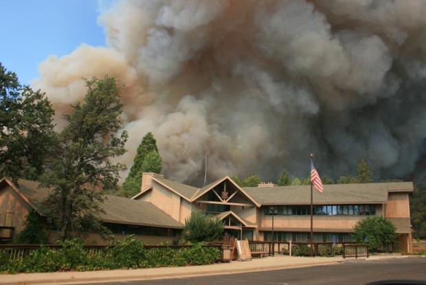
| #Rimfire: Heart-stopping sky above downtown Groveland (#photo posted on Facebook) #Yosemite Credit: Cory Stone |
NEW (8-23 10:00) Advisory Evacuation for Tuolumne City and Ponderosa Hills has been issued.
Evacuations: Evacuation center is located at the Mother Lode Fairgrounds in Sonora.
- An evacuation order has been ordered for the area north of Ferretti Road to Elderberry Road.
- An evacuation advisory has been issued for the community of Pine Mountain Lake.
- An evacuation advisory has been issued for the structures along Ferretti Road from Highway 120 to Pine Mountain Road and Highway 120 at the Yosemite National Park boundary west to Smith station.
Road Closures
Highway 120 remains closed to all inbound and outbound Yosemite National Park traffic. Ferretti Road and Highway 120 to Pine Mountain Drive and Ferretti Road, Smith Station at Highway 120, Cherry Lake at Highway 120, and Evergreen Road.
Black Rock Casino: Due to further developments, we are advising guests not to come to Black Oak Casino Resort. Please continue to check back for further updates.
Approximately 17,000 acres of this fire are in Yosemite National Park.
Southern Area Blue Team (Wilkins) is in Unified Command with CALFIRE (Lawshe).
Southern Area Blue Team (Wilkins) is in Unified Command with CALFIRE (Lawshe).
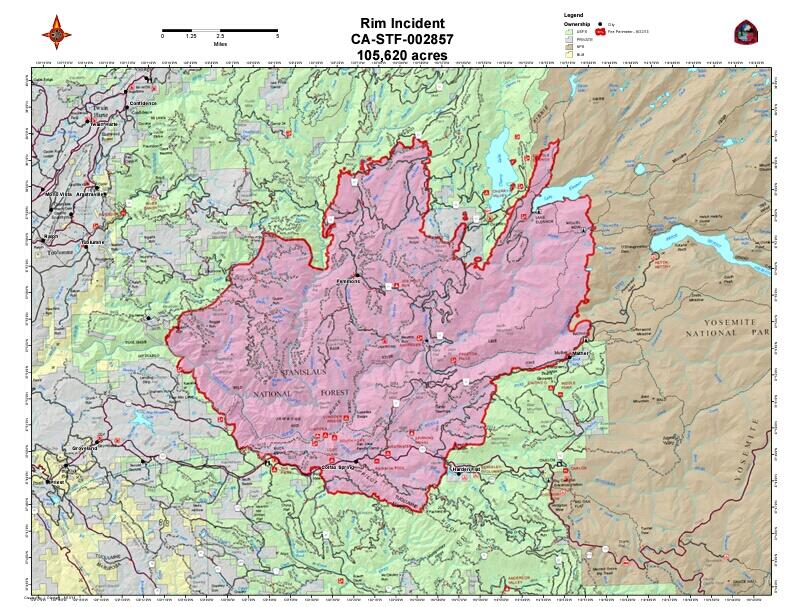
Update OSCC 8-23 19:000: 125,620 acres 5% contained
Approximately 11,000 acres of this fire is in Yosemite National Park.
Southern Area Blue Team (Wilkins) is in Unified Command with CALFIRE (Lawshe).
Communication Plan as of 8-23
SNF ECC 168.7500
C3 SUGARLOAF 168.0750
C10 SMITH PEAK 170.4125
C34 NORTH MTN 164.5250
NIFC TAC 2- IA 168.2000
NIFC TAC5- DIVA 166.7250
NIFC TAC6-DIV M 166.7750
NIFC TAC7- DIV D 168.2500
R5TAC4- DIV C 166.5500
R5TAC6- DIV R 158.2375
R5 PRO- DIV S 166.6625
VTAC14- DIV Q/B 159.4725
CMD A/G 168.6750
TAC A/G 169.7875
CALCORD MEDEVAC 156.0750
AIR GUARD 168.6250
Update OSCC 8-23 09:000: 105,620 acres 2% contained
Black Rock Casino: Due to further developments, we are advising guests not to come to Black Oak Casino Resort. Please continue to check back for further updates.
Update OSCC 8-26 0900: 149,780 acres, 15% contained, Unified Command Wilkins NC IMT1, Lawshe CA IMT1 No expected containment date.
The Rim incident is once again expected to continue to exhibit very large fire growth due to extremely dry fuels, strong winds and inaccessible terrain. Rapid fire growth and extreme fire behavior are hampering suppression efforts. Aerial resources are being utilized with heavy air tankers including the VLAT DC-10 and MAFFS prepping locations in advance of the fires spread to the East. Several Type 1 helicopters are providing point protection and cooling areas where direct line construction can be achieved safely. The forecasted high winds and high potential for long-range spotting however remains a significant concern for the potential of the fire to advance beyond the retardant lines and allow for fire spread into the communities of Tuolumne City, Twain Harte and Long Barn on the West side of the fire and East into the Hetch Hetchy Watershed and deeper into Yosemite National Park. Approx. 4500 structures are threatened on the Rim incident. Fire continues its eastward spread and is well into the Northwest corner of Yosemite National Park. A number of residents were evacuated in the Scott’s Ridge area South of HWY 120 yesterday evening. Due to inaccessible, Steep terrain and active fire behavior a combination of direct, where possible and indirect attack will be used on this incident. The availability of fixed wing aircraft is pertinent to the success of suppression operations.
Update OSCC 8-25 1950: 143,980 acres, 7% containedApproximately 17,000 acres of this fire are in Yosemite National Park.
Southern Area Blue Team (Wilkins) is in Unified Command with CALFIRE (Lawshe).
Update OSCC 8-25 0950:
Southern Area Blue Team (Wilkins) is in Unified Command with CALFIRE (Lawshe).
Southern Area Blue Team (Wilkins) is in Unified Command with CALFIRE (Lawshe).
133,980 acres, 7% contained
The incident is expected to continue to exhibit very large fire growth due to extremely dry fuels and inaccessible terrain. Rapid fire growth and extreme fire behavior are hampering suppression efforts.
Update OSCC 8-24 1950: 125,620 acres 5% contained.Southern Area Blue Team (Wilkins) is in Unified Command with CALFIRE (Lawshe).
129,620 acres, 7% contained
Update OSCC 8-24 09:000: 125,620 acres 5% contained. |
| RIM FIRE PERIMETER AND HOT SPOT MAP 8-24-13 MORNING |
 |
| #RimFire California Wildfire 8/23/13 pic.twitter.com/L5Op7RgKrg |
Southern Area Blue Team (Wilkins) is in Unified Command with CALFIRE (Lawshe).
 | |
|
SNF ECC 168.7500
C3 SUGARLOAF 168.0750
C10 SMITH PEAK 170.4125
C34 NORTH MTN 164.5250
NIFC TAC 2- IA 168.2000
NIFC TAC5- DIVA 166.7250
NIFC TAC6-DIV M 166.7750
NIFC TAC7- DIV D 168.2500
R5TAC4- DIV C 166.5500
R5TAC6- DIV R 158.2375
R5 PRO- DIV S 166.6625
VTAC14- DIV Q/B 159.4725
CMD A/G 168.6750
TAC A/G 169.7875
CALCORD MEDEVAC 156.0750
AIR GUARD 168.6250
Update OSCC 8-23 09:000: 105,620 acres 2% contained
Southern Area Blue Team (Wilkins) is in Unified Command with CALFIRE (Lawshe).
The Rim incident continues to increase in size expanding by 51,828 acres overnight, The Southern Blue team transitioned at 0600 hrs today. Approximately 4500 structures are threatened on the Rim incident.
The Rim incident continues to increase in size expanding by 51,828 acres overnight, The Southern Blue team transitioned at 0600 hrs today. Approximately 4500 structures are threatened on the Rim incident.
Fire Facts 8-23 0800:
Acres Burned: 105,620 Structures Threatened: 4,500
Containment: 2% Structures Destroyed: 16
Fire Start Date: August 17, 2013 Injuries: 1
Fire Cause: Under Investigation Total Personnel: 2,011
Cost to date: $5.4 Million
Rim Fire PIO at 805-727-4775
Containment: 2% Structures Destroyed: 16
Fire Start Date: August 17, 2013 Injuries: 1
Fire Cause: Under Investigation Total Personnel: 2,011
Cost to date: $5.4 Million
Rim Fire PIO at 805-727-4775
---------------------------------------
Update 8-23 08:000: Firefighter and public safety remains the highest priority.
The Rim Fire is located within the Stanislaus National Forest on the Groveland Ranger District. The fire continues to increase in size and burn actively through the day and night. It continues burning east and has crossed the Yosemite National Park boundary. The fire also continues burning west toward the community of Pine Mountain Lake and northwest. Direct suppression efforts are occurring in the vicinity of communities and structural defense is in place.
Update 8-23 0830: 105,620 Acres
 |
| RIM FIRE PERIMETER AND HOT SPOT MAP 8-23-13 MORNING |
Central Sierra Type 2 Incident Management team (Cooper) is in Unified Command with CALFIRE.
Fire has established itself in the Cherry Creek Drainage just west of North Mountain lookout.Firehas progressed to Quinn Ranch area and has burned up to the Woods Ridge. Eastward spread is along the south side of the Tuolumne River towards the community of Mather. Fire is expected to continue up the Tuolumne River canyon and continue its spread to the north and east.
Immediate threat to electrical power sources south of Tuolumne River, State Hwy 120, and north entrance of Yosemite. Structure defense for the community of Pine Mountain Lake, San Jose Camp and Spinning Wheel area. Firing operations were conducted around Camp Tawonga as the fire proceeded in the northwest spread.
Direct line suppression efforts are impeded due to difficult access, steep inaccessible terrain and extreme fire behavior.
Update 8-22 1830: #RimFire OES director via spothawk wildfire intelligence at 16:45 has the fire at 80,000 acres. #CaFire
Update 8-22 1730: Incident Overview
The Rim fire has transitioned into unified command with Cal Fire and Forest Service on August 21 at 2:00 p.m.Fire continues its eastward spread along Packerd Canyon Road and Pilot Ridge. Structure defense continues for San Jose Camp, Spinning Wheel and Tawonga Camp as the fire moves up the middle fork of the Tuolumne.
The fire continues to spread northwest burning past Butcher Knife Ridge and moving into Grapevine Creek; northeast up the Tuolumne River Drainage from the Gravel Range past Jones Point Lookout; and continue to spread southeast edge along Hwy 120 to the east.
Firing operations have begun on Ferretti Rd. as the fire progress west towards the community of Pine Mountain Lake. Direct suppression methods have been successful.
The availability of fixed wing air craft is pertinent to the success of suppression operations. The use of Maffs C-130s and the V-LAT DC-10 has greatly improved suppression efforts. Use of Military Rotary wing aircraft continues today.
In the next 24 hours the fire is expected to continue up the Tuolumne River canyon, and continue its spread to the north and east.
Due to inaccessible, steep terrain and active fire behavior a combination of direct and indirect attack will be used on this incident. Direct line suppression efforts are impeded by difficult access and steep inaccessible terrain. Active fire behavior today raises safety concerns for crews adjacent to the fire’s edge. Smoke exposure within the deep drainage of the Clavey River will be an issue for fire crews as well.
The South Central Sierra Interagency Incident Management Team is managing the Fire as of August 18, 2013 at 6:00 P.M.
Current Situation
Total Personnel - 1,356
Size - 53,866 acres
Percent Contained - 2%
Fuels Involved - Brush, Oaks, and Pine
Fire Behavior - The fire burned actively throughout the day and night. Active fire continued to move up Cherry Creek and the Tuolumne River Canyon.
Significant Events - Structure defense continues. Highway 120 is closed four miles west of Groveland Ranger Station and four miles east of Buck Meadows. Ferretti Road was closed. Access to the fire is still a concern for fire crews and equipment
Outlook / Planned Actions - Continued fixed wing air support.
Growth Potential - Extreme
Terrain Difficulty - Extreme
Remarks: The Rim Fire has transitioned into unified command with CalFire. Approximately 2,500 structures are threatened to the west of Ferretti Road north of Highway 120. Fire continues to spread eastward. Due to inaccessible, steep terrain and active fire behavior a combination of direct and indirect attack will be used on this incident.Current Weather
Wind Conditions 5-11 mph SW
Temperature 43-55 degrees
Humidity 61-76%
Update 8-22 1630: Officially 63,366 acres & 1% contained. Mandatory evacuation for Pine Mountain Lake, Unit 12, which is north and northeast of the airport. San Joaquin County OES strike team type-1's formed up at 16:00. Rendezvous Manteca. Last word heading to RIM. 4 XSJ-OA Engines, 20 person Crew, and 2 Chiefs (One Trainee).
Update 8-22 1430: NOTAM for the fire area: DC 3/4707 ZOA CA. FLIGHT RESTRICTIONS. GROVELAND, CA. Effective immediately until further notice.
Pursuant to 14 CFR Section 91.137(A)(2)
TEMPORARY FLIGHT RESTRICTIONS are in effect within a 15 nautical mile radius of 375152N/1200220W or the MODESTO /MOD/ VOR/DME 55.0 degree radial at 46.0 nautical miles at and below 10500 feet MSL to provide a safe environment for fire fighting aviation operations. Stanislaus National Forest telephone 209-532-3786 or freq 134.675/
The Rim Fire is in charge of the operation. Oakland / ZOA / ARTCC telephone 510-745-3331 is the FAA coordination facility.
http://tfr.faa.gov/save_pages/detail_3_4707.html
Update 8-22 0930: 53,866 acres, 2% contained
Central Sierra Type 2 Incident Management team (Cooper) is in Unified Command with CALFIRE.
Fire has established itself in the Cherry Creek Drainage just west of North Mountain lookout.
Fire operations have begun on Ferretti Rd. as the fire progresses west towards the community of Pine Mountain Lake.
Fire continues northwest spread and has burned past Grapevine Creek, continuing to burn north of Sugar Loaf Mountain Heli spot. Fire continues up Tuolumne River canyon and spread north and east.
Immediate threat to electrical power sources south of Tuolumne River, State Hwy 120, and north entrance of Yosemite.
Southeast Blue team will in-brief at 0900 and will start shadowing process for transition
Update 8-22 0730: Size 53,866 acres, Percent Contained 2% Contained
Fuels Involved Brush, Oaks, and Pine
Fire Behavior - The fire burned actively throughout the day and night. Active fire continued to move up Cherry Creek and the Tuolumne River Canyon.
Significant Events Highway 120 is closed four miles west of Groveland Ranger Station and four miles east of Buck Meadows. Ferretti Road was closed yesterday. Access to the fire is still a concern for fire crews and equipment
Outlook/Planned Actions Continued fixed wing air support.
Growth Potential Extreme
Terrain Difficulty Extreme
Remarks Two residences and seven outbuildings were lost along Packard Canyon Road on the eastward push of the fire. Approximately 2,500 structures are threatened to the west of the fire along Ferretti Road north of Highway 120. Due to inaccessible, steep terrain and active fire behavior a combination of direct and indirect attack will be used on this incident. Preparations were completed to secure fire camp if the fire were to threaten the Incident Command Post. Column induced weather preceded the fire front yesterday and rain halted the fires spread in the direction of camp. Other areas of the fire continued to burn actively with a southeasterly spread of the fire over Highway 120.

16,228 acres and 5% contained - 1080 Personnel.
Update 8-21 1900:The Rim fire has transitioned into unified command with Cal-Fire today.
Critical Resource Needs: Type One and Two hand crews, dozers, Type 3 Engine; Rotary and fixed wing aircraft.
Structure defense for the community of Pine Mountain Lake, San Jose Camp and Spinning Wheel area.
Active fire continued to move up Tuolumne River Canyon. Active fire and spotting on the west flank of the fire. Fire continues to burn actively to the east and southeast.
Approx. 2500 structures are threatened to the west of the Ferretti Road north of Highway 120.
Fire continues its eastward spread along Packard Canyon Road and Pilot RidgeUpdate 8-21 1330:
Update 8-20 1930: 10,170 acres, 0% contained
Central Sierra Type 2 Incident Management team (Cooper) is in command.
Blue team from Southern area (Wilkins) has been mobilized to this incident.
Update 8-20 1700: At 2:50 PM a strong thunderstorm was estimated to produce 1 to 2 inches of rain over the past hour. Another inch is possible. Doppler Radar indicating frequent lightning with the system
Drainage into the Tuolumne River is expected for this event.
Tuolumne County Sheriff's Office have started evacuating homes in the area of Clements Road off Highway 120.
Update 8-20 1500: The Rim Fire is 0% contained.
The north end of the fire has crossed the Clavey River and is burning in remote and steep terrain. The north end is not threatening any structures at this time.
Due to inaccessible, steep terrain and active fire behavior a combination of direct and indirect attack will be used on this incident. The fire burned actively with a southward spread of the fire over Highway 120. Direct line suppression efforts are impeded by difficult access and steep inaccessible terrain. A combination of direct and indirect attack will be used on this incident. Active fire behavior today raises safety concerns for crews adjacent to the fire’s edge. Smoke exposure within the deep drainage of the Clavey River will be an issue for fire crews as well.
There is a red flag warning for lightning today through Wednesday.
Size - 53,866 acres
Percent Contained - 2%
Fuels Involved - Brush, Oaks, and Pine
Fire Behavior - The fire burned actively throughout the day and night. Active fire continued to move up Cherry Creek and the Tuolumne River Canyon.
Significant Events - Structure defense continues. Highway 120 is closed four miles west of Groveland Ranger Station and four miles east of Buck Meadows. Ferretti Road was closed. Access to the fire is still a concern for fire crews and equipment
Outlook / Planned Actions - Continued fixed wing air support.
Growth Potential - Extreme
Terrain Difficulty - Extreme
Remarks: The Rim Fire has transitioned into unified command with CalFire. Approximately 2,500 structures are threatened to the west of Ferretti Road north of Highway 120. Fire continues to spread eastward. Due to inaccessible, steep terrain and active fire behavior a combination of direct and indirect attack will be used on this incident.Current Weather
Wind Conditions 5-11 mph SW
Temperature 43-55 degrees
Humidity 61-76%
Update 8-22 1630: Officially 63,366 acres & 1% contained. Mandatory evacuation for Pine Mountain Lake, Unit 12, which is north and northeast of the airport. San Joaquin County OES strike team type-1's formed up at 16:00. Rendezvous Manteca. Last word heading to RIM. 4 XSJ-OA Engines, 20 person Crew, and 2 Chiefs (One Trainee).
 |
| RIM FIRE PERIMETER AND HOT SPOT MAP 8-22-13 AFTERNOON |
Pursuant to 14 CFR Section 91.137(A)(2)
TEMPORARY FLIGHT RESTRICTIONS are in effect within a 15 nautical mile radius of 375152N/1200220W or the MODESTO /MOD/ VOR/DME 55.0 degree radial at 46.0 nautical miles at and below 10500 feet MSL to provide a safe environment for fire fighting aviation operations. Stanislaus National Forest telephone 209-532-3786 or freq 134.675/
The Rim Fire is in charge of the operation. Oakland / ZOA / ARTCC telephone 510-745-3331 is the FAA coordination facility.
http://tfr.faa.gov/save_pages/detail_3_4707.html
 |
| RIM FIRE PERIMETER AND HOT SPOT MAP 8-22-13 MORNING |
Central Sierra Type 2 Incident Management team (Cooper) is in Unified Command with CALFIRE.
Fire has established itself in the Cherry Creek Drainage just west of North Mountain lookout.
Fire operations have begun on Ferretti Rd. as the fire progresses west towards the community of Pine Mountain Lake.
Fire continues northwest spread and has burned past Grapevine Creek, continuing to burn north of Sugar Loaf Mountain Heli spot. Fire continues up Tuolumne River canyon and spread north and east.
Immediate threat to electrical power sources south of Tuolumne River, State Hwy 120, and north entrance of Yosemite.
Southeast Blue team will in-brief at 0900 and will start shadowing process for transition
Update 8-22 0730: Size 53,866 acres, Percent Contained 2% Contained
Fuels Involved Brush, Oaks, and Pine
Fire Behavior - The fire burned actively throughout the day and night. Active fire continued to move up Cherry Creek and the Tuolumne River Canyon.
Significant Events Highway 120 is closed four miles west of Groveland Ranger Station and four miles east of Buck Meadows. Ferretti Road was closed yesterday. Access to the fire is still a concern for fire crews and equipment
Outlook/Planned Actions Continued fixed wing air support.
Growth Potential Extreme
Terrain Difficulty Extreme
Remarks Two residences and seven outbuildings were lost along Packard Canyon Road on the eastward push of the fire. Approximately 2,500 structures are threatened to the west of the fire along Ferretti Road north of Highway 120. Due to inaccessible, steep terrain and active fire behavior a combination of direct and indirect attack will be used on this incident. Preparations were completed to secure fire camp if the fire were to threaten the Incident Command Post. Column induced weather preceded the fire front yesterday and rain halted the fires spread in the direction of camp. Other areas of the fire continued to burn actively with a southeasterly spread of the fire over Highway 120.

 |
| RIM FIRE PERIMETER & HOT SPOT MAP |
 |
| RIM FIRE PERIMETER MAP |
Update 8-21 1930: 16,228 acres, 5% contained
Central Sierra Type 2 Incident Management team (Cooper) is in Unified Command with CALFIRE. The Blue Team (Wilkins) will in-brief tomorrow at 0900 hours.
The line continues to hold on Highway 120. Structure defense for the community of Pine Mountain Lake, San Jose Camp, Tawonga Camp, and Spinning Wheel area. Early intake equipment for the Hetch Hetchy aqueduct is at risk. Direct line suppression efforts are impeded by difficult access, steep inaccessible terrain, and active fire behavior, raising safety concerns for crews adjacent to the fires edge. Smoke exposure, within the deep drainage of the Clavey River will be an issue for crews on the fire. Today the use of MAFFS C-130s and the V-LAT
DC-10 greatly aided suppression efforts. Military rotary wing aircraft use continues.
PM209 16,228 acres and 5% contained - 1080 Personnel.
Update 8-21 1900:The Rim fire has transitioned into unified command with Cal-Fire today.
Critical Resource Needs: Type One and Two hand crews, dozers, Type 3 Engine; Rotary and fixed wing aircraft.
Structure defense for the community of Pine Mountain Lake, San Jose Camp and Spinning Wheel area.
Active fire continued to move up Tuolumne River Canyon. Active fire and spotting on the west flank of the fire. Fire continues to burn actively to the east and southeast.
Approx. 2500 structures are threatened to the west of the Ferretti Road north of Highway 120.
Fire continues its eastward spread along Packard Canyon Road and Pilot Ridge

Update 8-20 1930: 10,170 acres, 0% contained
Central Sierra Type 2 Incident Management team (Cooper) is in command.
Blue team from Southern area (Wilkins) has been mobilized to this incident.
Update 8-20 1700: At 2:50 PM a strong thunderstorm was estimated to produce 1 to 2 inches of rain over the past hour. Another inch is possible. Doppler Radar indicating frequent lightning with the system
Drainage into the Tuolumne River is expected for this event.
 |
| Rim Fire Near Groveland Ranger Station Credit: Inciweb |
Update 8-20 1500: The Rim Fire is 0% contained.
The north end of the fire has crossed the Clavey River and is burning in remote and steep terrain. The north end is not threatening any structures at this time.
Due to inaccessible, steep terrain and active fire behavior a combination of direct and indirect attack will be used on this incident. The fire burned actively with a southward spread of the fire over Highway 120. Direct line suppression efforts are impeded by difficult access and steep inaccessible terrain. A combination of direct and indirect attack will be used on this incident. Active fire behavior today raises safety concerns for crews adjacent to the fire’s edge. Smoke exposure within the deep drainage of the Clavey River will be an issue for fire crews as well.
There is a red flag warning for lightning today through Wednesday.
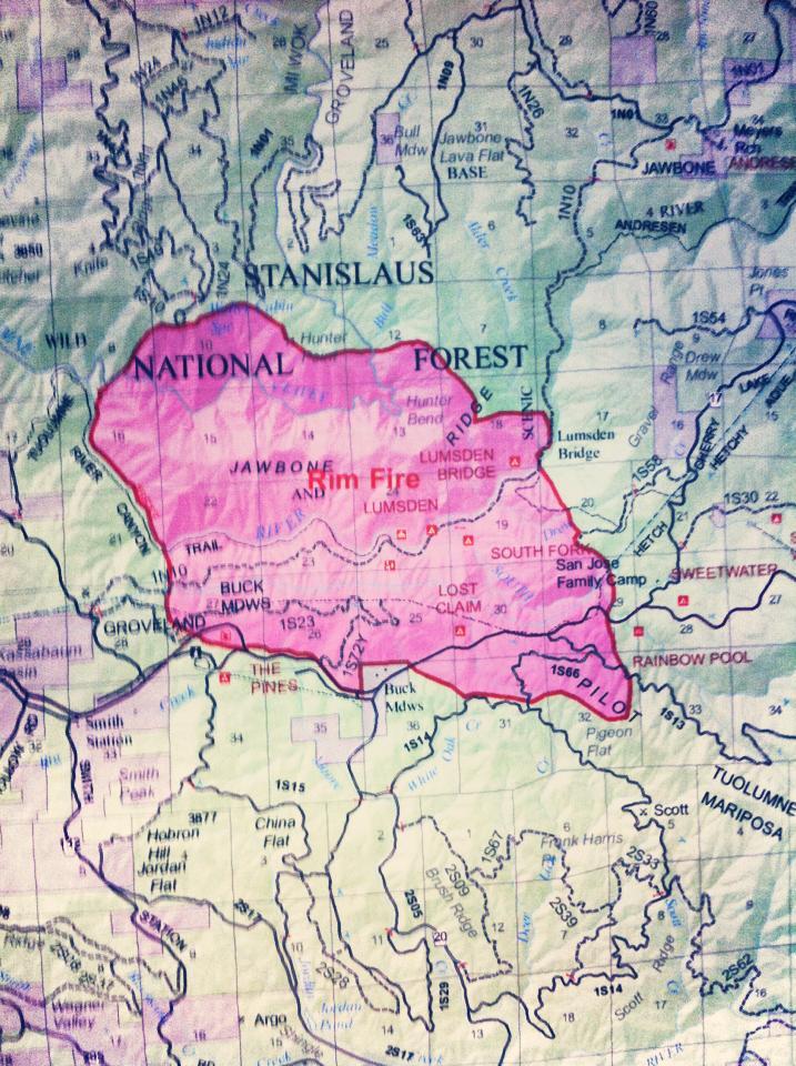 |
| Perimeter Map of the Rim Fire Tuolumne County Credit: Leah Ives-Phillips |
 |
| Firefighters from the ACFD, Oakland FD, Hayward FD, East Bay Regional Parks & Fremont FD are on their way to the Rim Fire in Stanislaus County. Attached are a few photos from the Strike Team's briefing this afternoon. |
Update 8-19 1900: 800 acres, 0% contained
No report due to protection of ICP
Update 8-19 1900: The Buck Meadows area is being evacuated. An evacuation center is at Tioga High School located on 19304 Ferretti Road, Groveland, California.Update 8-19 1800: Evacuation Center Being Reassessed
This afternoon Mariposa County officials contacted Tioga High School about opening an evacuation center at the school, and the Forest Service announced that the site would be used for that purpose. Tracie Riggs of the Tuolumne County Office of Emergency Services says the location is being reassessed, and a decision will likely be made within the next hour about where evacuees should go for the night.
#Evacuations Buck Meadows area Mariposa County
Highway 120 closed.
There is a red flag warning for lightning today through Wednesday.
Video MAFFS 4 on The Rim Fire
Update 8-19 1500:
#RimFire blow up. large header building fire has jumped Tuolumne River and Highway 120 #Evacuations #loc Buck Meadows area Mariposa County is burning up a north facing slope to the south of the Clavey River towards Jawbone Ridge on the Groveland Ranger District of the Stanislaus National Forest. Firefighting aircraft are on scene with ground units en route to the very isolated and steep Clavey River Canyon area about one and a half miles east of the confluence with the Tuolumne River.
The fire continues to move up the south slope on the Clavey River drainage. The spread appears to be caused by material rolling out with up slope runs on Jawbone Ridge. Fixed wing aircraft have been successful in holding the fire to the top of Jawbone Ridge between the Tuolumne River and the Clavey River but is expected to continue it’s up canyon spread.
Direct line suppression efforts are impeded by difficult access and steep inaccessible terrain. A combination of direct and indirect attack will be uses on this incident. Active fire behavior today raises safety concerns for crews adjacent to the fire’s edge. Smoke exposure within the deep drainage of the Clavey River will be an issue for fire crews as well.Currently assigned to the fire are 5 type1 crews, 1 type2 crew, 4 helicopters, 2 engines, 1 dozers, 166 personnel and a number of fixed wing aircraft spotting and dropping retardant.
Dozers are working on Forest Road 1N01 for contingency and safety zones. The approved designate Helispot is located at 3300 feet at the top of Jawbone Ridge. Values at risk include the Wild and Scenic Tuolumne River.
The gate to Lumsden Road is closed and the CHP has closed the Rim of the World overlook on Hwy 120 for traffic safety.
The management of the Rim Fire has now been transferred to Incident Commander David Cooper and the South Central Sierra Interagency Incident Management Team.
Size 200 acres
Fuels Involved - Shrubs, Oaks, Pine trees
Outlook/Growth Potential - High
Terrain Difficulty - Very difficult, Steep Terrain
Current Weather - Temperature 90 degrees
Update 8-18 1000: Tuolumne County 200 acres, 0% contained
This afternoon Mariposa County officials contacted Tioga High School about opening an evacuation center at the school, and the Forest Service announced that the site would be used for that purpose. Tracie Riggs of the Tuolumne County Office of Emergency Services says the location is being reassessed, and a decision will likely be made within the next hour about where evacuees should go for the night.
#Evacuations Buck Meadows area Mariposa County
Highway 120 closed.
There is a red flag warning for lightning today through Wednesday.
Video MAFFS 4 on The Rim Fire
Update 8-19 1500:
#RimFire blow up. large header building fire has jumped Tuolumne River and Highway 120 #Evacuations #loc Buck Meadows area Mariposa County is burning up a north facing slope to the south of the Clavey River towards Jawbone Ridge on the Groveland Ranger District of the Stanislaus National Forest. Firefighting aircraft are on scene with ground units en route to the very isolated and steep Clavey River Canyon area about one and a half miles east of the confluence with the Tuolumne River.
The fire continues to move up the south slope on the Clavey River drainage. The spread appears to be caused by material rolling out with up slope runs on Jawbone Ridge. Fixed wing aircraft have been successful in holding the fire to the top of Jawbone Ridge between the Tuolumne River and the Clavey River but is expected to continue it’s up canyon spread.
Direct line suppression efforts are impeded by difficult access and steep inaccessible terrain. A combination of direct and indirect attack will be uses on this incident. Active fire behavior today raises safety concerns for crews adjacent to the fire’s edge. Smoke exposure within the deep drainage of the Clavey River will be an issue for fire crews as well.Currently assigned to the fire are 5 type1 crews, 1 type2 crew, 4 helicopters, 2 engines, 1 dozers, 166 personnel and a number of fixed wing aircraft spotting and dropping retardant.
Dozers are working on Forest Road 1N01 for contingency and safety zones. The approved designate Helispot is located at 3300 feet at the top of Jawbone Ridge. Values at risk include the Wild and Scenic Tuolumne River.
The gate to Lumsden Road is closed and the CHP has closed the Rim of the World overlook on Hwy 120 for traffic safety.
The management of the Rim Fire has now been transferred to Incident Commander David Cooper and the South Central Sierra Interagency Incident Management Team.
 |
| RIM FIRE - TUOLUMNE / MARIPOSA COUNTIES LOCATION AND PERIMETER MAP |
Update 8-19 1000: Cooper’s Type 2 team transitioned at 1800 hours last night.
800 acres, 0% contained. Fire continues to move up the south slope on the Clavey River drainage. Fire continues to hold on Jawbone Ridge between the Tuolumne River and the Clavey River
Update 8-18 1000: 450 acres and 0% contained.
Cooper’s Type 2 Team has arrived and will tentatively transition tonight.
Current Situation 8-18 0900Size 200 acres
Fuels Involved - Shrubs, Oaks, Pine trees
Outlook/Growth Potential - High
Terrain Difficulty - Very difficult, Steep Terrain
Current Weather - Temperature 90 degrees
Update 8-18 1000: Tuolumne County 200 acres, 0% contained
Transition to Central Sierra Interagency (Cooper) at 1800 hours.
Fire had a rapid rate of spread moving north, east, and west in the Clavey River drainage.
Update 8-18 0800: The fire was observed overnight. No report of activities is available at this time., Air Attack overflight is scheduled for 0800 this morning. A type 2 incident management team has been ordered along with other support units and equipment. A Strike Team (5 engines 20 people) form the Sierra NF has arrived on the Stanislaus NF.
Overview
The Rim Fire is burning up a north facing slope to the south of the Clavey River towards Jawbone Ridge on the Groveland Ranger District of the Stanislaus National Forest. Firefighting aircraft are on scene with ground units en route to the very isolated and steep Clavey River Canyon area about one and a half miles east of the confluence with the Tuolumne River.
Basic Information
Incident Type Wildfire
Cause Under Investigation
Date of Origin Saturday August 17th, 2013 approx. 03:15 PM
Location: Groveland Ranger District of the Stanislaus National Forest just outside of Buck Meadows on Highway 120, Rim of the World Vista Point at Lumsden Road.FRA
3 miles northeast of Groveland, near Clavey River Canyon
GPS: 37.857 x 120.087 ROS: *
ROC: *
Structure Threats: *
Concerns: *
Resources: ROSS shows Buying Team and Type 2 IMT request.
Cooperating Agencies: *
Weather Info: Temperatures are expected to be in the upper 90's with a relative humidity of 11 to 16%. Winds should be out of the east at 6 to 12 mph with gusts up to 22 mph.
Special Conditions: *
Other Comments: *
Radio Frequencies: *
Maps: *
Agency Website: *
Online Scanner: *
Live Video: *
Web Cams: http://www.pmlaa.org/webcams.htm
---------------------------------------------


